
|
|

   
|
THREE GORGES PROJECT, CHINA

Yangtze River Water Conservation Committee, which is
responsible for the water management of the Yangtze River Basin and the Three
Gorges Project, chose GWN’s suite of infrastructure design and management
software for the project. The products assist in the design and construction
work of the Yangtze River dam and hydroelectric power project. The total
project, estimated at $11,6 billion, includes an enormous concrete gravity
dam 185 meters tall and about 2,000 meters long, which will have power
generating capability of 18,200 Mw and will also provide flood control. The
project will create a reservoir with a flood storage and a channel system,
which will assist in flood management in the Yangtze Valley. The second step
will be construction of a system to transport water from southern China
to regions in north, east and west.
GWN software, GWN-DTM and GWN-COGO, was chosen for use on the new Hong Kong Airport at Chek Lap Kok Island. The Hong Kong Government Civil Engineering Department performed extensive testing on the software and determined that the GWN products would best meet their needs for design and earthwork calculations. The new airport must be completed prior to the 1997 turnover date and the engineering work must meet strict deadlines and the high requirement for accuracy. GWN software provides the speed, power and flexibility to meet these criteria. U.S. ARMY CORPS OF ENGINEERS  The U.S. Army Corps of Engineers placed stringent criteria for the 20 digital terrain modeling/site design software they evaluated. GWN-DTM came through with flying colours. The product has been used in e.g. defining slopes for armored vehicles movements in addition to land based design and other uses. CHICAGO CIRCULAR DESIGN TEAM GWN-COGO will be used for the alignment design of the $750 million light rail transit system design project as well as for cross-sections of existing intersections and for surveying data downloading. GWN-COGO became the winner after extensive testing by Orange County (Metro Los Angeles). GWN's coordinate geometry software is used exclusively for the surveying and related work by the Public Works Department of this metropolitan county.  GWN and its South Korean partner, Union Systems Inc., won the contract for the City of Seoul Land Registration Management System. The system will utilize MicroStation and GWN’s GIS on HP9000. GWN customized its GIS modules to correspond to the requirements of the project and the software was also localized into Hangul. The GIS system for the Land Register Service will assist in defining land policies, in urban planning and development planning for the City and surrounding areas, utilities management, analysis of the transportation system and in the overall administration of civil affairs. Tasks include e.g. registration, register inquiries, cadastral map management, development project information management and management of historical data. GWN’s products are used in construction of topology file, creation of cadastral maps and storage of these maps, linking of non-graphic and graphic data, and for access, manipulation and viewing of the data. The project is executed in two parts. First part, currently underway, is a pilot covering a portion of the City of Seoul and utilizes six HP workstations. After the 12 month pilot, the system will be expanded to the whole City and its population of 9 million. 
GWN software was used for a Master Planning Study of environmentally sensitive areas in this Town adjacent to one of Canada’s National Parks. Due to the restriction on development in the parks, there is increasing pressure to develop tourist facilities on adjoining areas. The GWN-GIS software was used to determine the potential impact of development on land use and hence on environmentally sensitive areas and wildlife corridors. SUGARCANE BOARD OF THAILAND GWN Systems and its local partner won a bid against tough international competition to implement a GIS system for the Sugarcane Board of Thailand. 
17 Danish municipalities or (municipal) surveying agencies are using GWN-FM and other GWN GISPro modules for cadastral mapping. Digitized airphotos are used as a base to define parcel maps, which are then overlayed with the of historical parcel maps to determine actual boundaries and tax base.
City of Longmont uses GWN-FM and GWN GISPro extensively for their needs in public utilities mapping and management. The City, located near Denver, Colorado, first purchased GWN-MMS in 1991 for their Water/Wastewater Department, who are now using several GWN-MMS (GWN-FM) and GWN-GIS packages. Other city departments have since adopted the GWN products as well. In the first phase the city used a scanned sanitary sewer map to attach the information to the database using the GWN-MMS. In the spring of 1992 the city had an aerial mapping done producing the information in digital format. The department has now adjusted the old wastewater system map to match the digital files from the aerial mapping. The total number of database records includes 4442 sanitary sewer manholes and 4200 pipe segments; the total mileage of pipes in the system is approximately 200 miles. 
This was a project for Mapping of Wildlife and Aquatic Habitat along the Dempster Highway and the Ingraham Trail commissioned by the Government of North West Territories. Using GWN-GIS software, an extensive evaluation was undertaken of the wildlife and aquatic resources along two sections of highway in Northern Canada. The objective of the project was to identify areas which required habitat restoration. Locations of key habitat and restoration areas were geographically linked to the database and to UTM reference points. Data acquisition was done using conventional and GPS methods. The final product will enable the client to manage the restoration of critical wildlife and aquatic sites along these sections of highway. ALGONQUINS OF GOLDEN LAKE FIRST NATION GIS 
This project involved the implementation of a GIS system for the negotiations department of the Algonquins of Golden Lake First Nation in Ontario. A unique approach was taken whereby training of their own staff was paramount. Instead of the traditional training style the program was specifically tailored and focused on their GIS needs specifically. In addition the training would be used to implement their GIS system with their geographic and attribute data. The project was successfully completed with a number of specific themes. The primary object was to be able to identify geographically all the crown lands in the claim area. Base thematic layers for roads, rivers and lakes were used to defined the claim boundary which covered some 35,000 square kilometres of land. In addition the boundaries of 180 plus townships were delineated using base data plus scanned one-off maps. Mining, hunting themes were also defined at this phase. This would be an ongoing program where GWN would assist them on an as required basis. 
GWN assisted the Alberta Metis Settlement Transition Council in their Land Registry System and in the preparation of a GIS system for the Elizabeth Settlement in North Eastern Alberta. The consulting work entailed the review of source code and applications required for their in-house maintenance of the database model. The Metis Settlement Council is in the process of passing on many of their functions to the individual settlements, however the land titling and registry portion will probably be kept within the Provincial government. The objective of the GIS was to link the geographical data directly to the land registry database. Recommendations were made to update the registry information to facilitate better integration with future GIS systems. 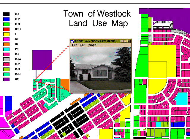
The Town of Westlock, Alberta retained GWN to provide them with a GIS feasibility report. This feasibility study included a detailed user survey to determine the needs and objectives of the town. Consequently a three year implementation plan was drawn up. The first phase was completed in the summer of 1996. This included the creation of a topologically clean cadastral map base from which tax assessment data could be linked. In addition three other utility themes were completed. These included water distribution, sanitary and storm drainage. As built plans of these utilties were used. Data models were discussed in detail with the client. The tax data were assembled from their IBM mini. In the process the MISAM parcels were updated and disrepancies in their financial data were addressed. A major interest for the town is the use of the GIS system for economic development. This is in addition to land use planning and operations and maintenance. The system is to be used in desktop client-server environment with integration to their new PC based financial software and tax assessment software. 
Amoco Petroleum retained GWN to develop a digitally based AM/FM system for a 50km section of their pipeline. This system was designed as a prototype which would lead to a system which would cover the entire 2,500 km length of pipelines under Amoco’s operation in Alberta. This system allowed maintenance operators to query pipeline characteristics, locate valves, retrieve associated data such as digital photographs, documents and even video data. An additional objective which was achieved was the ability to use buffering to obtain residents and structures within a mile (1.6 km) of the pipeline for emergency measures and other purposes. Using our approach this would be an incremental GIS system which will allow Amoco to add additional categories and features as the need arises. Being an Open system it will provide a venue for future enhancements and customization. GWN was chosen to supply a custom MDL code application to Alberta Transportation, a department of the provincial government, to automate the process of creating “As-Built Roadway Alignment” maps for Alberta’s Secondary Highway System. Alberta Transportation required a user friendly system that would automate or expedite the work required to accurately reference highway surface inventories, construction contracts, sign locations and administrative jurisdictions (e.g. municipalities). The application was required to support input of survey data from registered survey plans and creation of a parcel map of the right-of-way; to combine the parcel map with a roadway alignment (centerline) and create a table annotating survey pin types, locations and distance; and to project the resulting parcel map and centerline into a Transverse Mercator map. 
GWN was contracted by EPCOR (Edmonton Power) to provide software services which would prove that it is possible to do electrical network flow tracing within the cadastral map sheets and databases that currently exist within Edmonton Power. This required custom development in the MicroStation environment and modification of existing graphical information and databases to allow the electrical network flow tracing to occur. The project was to illustrate the principles involved and give a clear understanding of the work that would have to follow in 1997 in order to have a complete working system. The scope of the work centered around tracing the W12 circuit from the Woodcroft Substation and the 650 Substation circuits which are fed from the W12 circuit. The 650 Substation feeds circuits 651, 653, 654, 655, and 656. The Phase I project was completed on time and budget by December 1996. Phase II is slated for production in 1997.
|
|
Copyright © 2003 GWN Technologies International (A Division of Ecosoft System Inc.) |

